

Metro Manila, Philippines – San Miguel Aerocity Inc. (SMAI), developer of the New Manila International Airport (NMIA), said that its airport development in Bulacan is being built with long term flood mitigation measures, designed to protect both the airport and surrounding communities from long-existing flooding risks in the province’s low-lying coastal areas.
SMAI pushed back against claims circulating online linking the airport to recent flooding following weeks of heavy rains. The company said the claims have not been accompanied by hydrological data, technical analysis, or any identified expert source establishing such a connection.
“NMIA did not cause Bulacan’s flooding. This is a problem the province has had to contend with for many generations. Our responsibility is to make sure the airport is built for these conditions, and that its development does not make flooding in the province worse,” the company said.
Flooding in Bulacan predates NMIA by many, many decades, and is driven by a combination of the province’s low-lying geography, heavy rainfall and river flows from upstream areas, limited river capacities, and land subsidence. In addition, rising sea levels and continued development across the province, are adding pressure to an already complex watershed.
Extensive research, engineering studies
According to SMAI, extensive research, engineering studies, and hydrological modeling for the project conducted by Danish international firm DHI started as far back as 2018 have resulted to a multi-year process to address flooding.
The studies examined the surrounding rivers and coastal waters, how waters moved throughout the area, historical typhoons and storms surges, and land subsidence. They also looked at how raising and developing the airport site could affect drainage and flood levels in surrounding and upstream communities.
A river flood assessment, along with a larger Bulacan flood mitigation study, was also conducted by DHI in 2019. This study determined that in order to mitigate flooding risks related to the airport, an engineered channel that would improve water flow needed to be developed.
In 2021, UK-based global engineering firm Mott McDonald consolidated all of DHI’s models and baseline data to align the project with international lender standards—including the environmental and social performance standards of the International Finance Corporation (IFC).
It was also at this stage where long-term land subsidence data and extreme climate change forecasts up to the year 2100 determined that the airport platform must be raised to at least 3.85m to 5.50m MSL at its center.
As the project transitioned to construction, Dutch marine engineering firm Boskalis and DHI developed an alternative to extensive river widening, to address land constraints and avoid impacting mangrove areas.
This proposal, to deepen riverbeds while narrowing their bottom width to achieve target flows, was applied to three major rivers around the airport—the Maycapiz-Taliptip (or Alipit) River, Santa Maria River and the Meycauayan River.
SMC’s Bulacan river cleanups
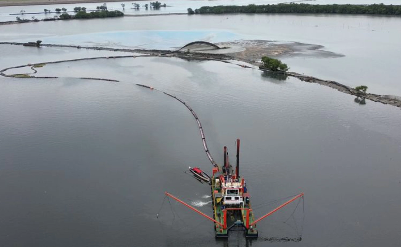
From 2022 to 2024, through its long-running Better Rivers PH initiative, San Miguel Corporation (SMC) removed over 1 million metric tons of silt and waste from the three rivers—achieving the target bottom width and depth for each river.
The work being done, at no cost to the government, has helped increase the capacity of the waterways that were previously shallow and heavily silted — improving their ability to carry water from upstream areas out to Manila Bay.
SMC’s river dredging and cleanup efforts have become an integral part of its corporate social responsibility (CSR) commitment and, as such, pushed its expansion to all over Bulacan province. As of August 18, 2026, the company has removed over 4.3 million metric tons of silt and wastes from rivers in Bulakan town; the Bocaue, Guiguinto, and Balagtas rivers; rivers in Malolos; the Obando, Meycauayan, and Marilao rivers, and the Labangan-Angat River.
Continued maintenance of the rivers around the airport is part of the long-term commitment of SMAI to the government. It calls for flood mitigation to safeguard both communities and the airport itself—a vital infrastructure whose ownership will eventually transfer to the government.
Not Reclamation
SMAI also clarified that NMIA is not a reclamation project. It is a land development project on existing, titled land in Bulakan that had long been used as commercial fishponds and had become increasingly prone to inundation over time.
Unlike reclamation, which creates new land on water, NMIA involves raising and preparing existing land for development. The Department of Environment and Natural Resources (DENR) has previously made the same distinction.
SMAI said the conditions of the site were known and taken into account in selecting Bulacan as the site for the new airport. The location provides a large contiguous area required for a new international gateway and future expansion, while remaining close to Metro Manila and major economic centers.
It can also be connected to Luzon’s expressway network and provides space for additional runways, terminals and other infrastructure that cannot be accommodated at the existing Ninoy Aquino International Airport (NAIA).
Larger challenge of flooding in Bulacan
SMAI stressed that the measures being undertaken for the airport’s and surrounding areas should not be confused with the much larger challenge of managing flooding across Bulacan.
The province is part of an interconnected network of rivers and waterways carrying rainfall and runoff from inland areas toward Manila Bay. As development continues upstream and more open areas are replaced by buildings, roads, and other paved surfaces, less rainwater is absorbed into the ground, and more water reaches rivers.
Low-lying coastal areas such as Bulakan, Obando, and Hagonoy face land subsidence, high tides and rising sea levels where flooding are experienced even when there is no rain. This is also making it increasingly difficult for water coming from upstream to drain into Manila Bay. SMAI said these conditions require a broader approach that looks at the entire watershed rather than individual rivers or flood-control projects, in isolation.
“Protecting the airport and nearby areas and addressing Bulacan’s larger flooding problems, are two separate challenges,” the company said. “We can engineer NMIA for the conditions of the site and mitigate its impact. But protecting communities across Bulacan requires looking at the whole system—from the water coming from upstream, to the rivers carrying it, to the coastal areas where it eventually has to drain.”
While SMC continues to conduct river dredging to increase the water holding capacity of the surrounding rivers of NMIA and the upstream rivers in nearby communities, this may not be enough to handle the more severe rains on certain areas which may require more structural intervention like widening the river channels or building more permanent river dikes. Coastal and low-lying areas like in nearby cities of Navotas and Malabon may need to put up a floodgate system to control entry of water during high tide and storm surges and pumping stations to remove the water out of their catchment area.
SMAI said it will continue implementing NMIA’s environmental and flood-mitigation commitments, while working with government agencies and local governments on broader measures to improve river capacity and flood resilience across Bulacan.