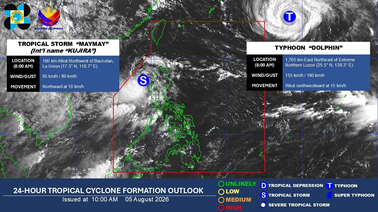


Metro Manila, Philippines – Tropical Storm Maymay continued to move toward Northern Luzon on Wednesday, August 5, and could make landfall over Ilocos Sur or La Union by the afternoon or evening, prompting state weather bureau PAGASA to keep Tropical Cyclone Wind Signal No. 2 over parts of the region.
As of 7 a.m., the center of Maymay was estimated 170 kilometers west of Bacnotan, La Union.
The storm packed maximum sustained winds of 65 kilometers per hour near the center, gusts of up to 80 kph and was moving slowly westward.
The state weather bureau, however, said the storm’s movement remained erratic and was forecast to turn eastward toward the Philippine landmass.
“Sa kasalukuyan, medyo nagwo-wobble pa po o nagiging paiba-iba pa iyong pagkilos na ito. But generally, nakikita po natin na eastward iyong magiging movement niya o patungo siya dito sa ating landmass,” PAGASA weather specialist Grace Castañeda-Carpio said.
[Translation: At present, its movement is still wobbling or changing. But generally, we expect it to move eastward toward the Philippine landmass.]
The weather bureau said Maymay is expected to maintain tropical storm strength before landfall before weakening into a tropical depression on Thursday morning as it crosses Northern and Central Luzon. It may further weaken into a low-pressure area by Thursday afternoon or evening.
Signal No. 2 remained in effect over parts of Ilocos Sur, La Union, Pangasinan, Abra, Mountain Province and Benguet, where gale-force winds of 62 to 88 kph could pose a minor to moderate threat to life and property.
Signal No. 1 remained hoisted over the rest of the Ilocos Region, the Cordillera Administrative Region, Cagayan Valley and portions of Central Luzon.
Castañeda-Carpio warned residents to remain alert as the storm’s winds could still damage vulnerable structures.
“Posible pa rin magdulot ng mga minor damages o minimal damages, lalong-lalo na sa mga structures na gawa sa light materials.”
[Translation: It may still cause minor or minimal damage, especially to structures made of light materials.]
Aside from strong winds, Maymay and the southwest monsoon are expected to dump heavy rain over much of Luzon in the coming days.
PAGASA forecast 100 to 200 millimeters of rain over La Union, Pangasinan, Zambales and Benguet through Thursday, while Ilocos Sur, Mountain Province, Ifugao, Tarlac, Pampanga, Nueva Ecija, Bataan and Bulacan could receive 50 to 100 millimeters.
Metro Manila, Rizal, Cavite, Laguna, Batangas and Occidental Mindoro are also expected to experience 50 to 100 millimeters of rain due to the enhanced southwest monsoon.
Meanwhile, PAGASA is also monitoring Typhoon Dolphin outside the Philippine Area of Responsibility.
While Dolphin has no direct effect on the country, Castañeda-Carpio said its circulation could enhance the southwest monsoon later this week and bring stronger winds to Batanes.
PAGASA said most of Luzon is expected to continue experiencing periods of rain through the weekend as the southwest monsoon remains enhanced by the two weather systems.