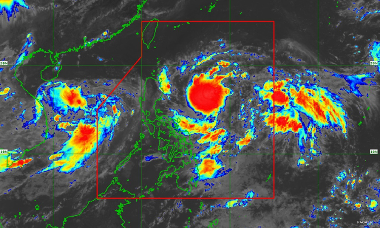

Metro Manila, Philippines — “Carina” has strengthened into a tropical storm, the Philippine Atmospheric, Geophysical and Astronomical Services Administration (PAGASA) said on Saturday afternoon, July 20.
In a 5 p.m. bulletin, PAGASA said Tropical Storm Carina (international name: Gaemi) was last seen at 630 kilometers (km) east of Casiguran, Aurora, moving west northwestward at 15 km per hour (km/h).
No storm alerts have been issued yet. However, PAGASA weather specialist Daniel James Villamil indicated that Signal No. 1 may be raised over extreme northern Luzon and the eastern portion of northern Luzon, depending on the track of “Carina.”
PAGASA noted that strong to gale-force winds extend outwards up to 250 km from the center of “Carina.”
The tropical storm has maximum sustained winds of 65 km/h near the center and gustiness of up to 80 km/h.
“Carina” and “Butchoy,” which has since left the Philippine Area of Responsibility (PAR) as a tropical depression, were enhancing the southwest monsoon, or habagat, on Saturday.
The enhanced habagat is expected to bring rains over the western portion of Luzon until Tuesday, government meteorologists said.
The weather bureau earlier advised authorities in Kalayaan Islands to prepare for moderate to heavy rainfall on Saturday that may cause flooding and landslides.
PAGASA said “Carina” may further intensify into a typhoon by Tuesday, though the possibility of rapid intensification cannot be ruled out.
The tropical storm is expected to have a mainly offshore path over the next five days and remain far from landmass, state meteorologists added.
The bureau also warned small vessel mariners of moderate seas over the coastal waters along the eastern seaboard of Mindanao due to “Carina” and the habagat.
Weather on Saturday evening
According to the 4 p.m. advisory, PAGASA said the southwest monsoon may bring cloudy skies with scattered rain showers and thunderstorms over Negros Occidental, Antique, Palawan, Occidental Mindoro, Zambales, and Bataan on Saturday.
It may also cause partly cloudy to cloudy skies with isolated rain showers or thunderstorms over Metro Manila, Mindanao, Cavite, Laguna, Batangas, the rest of Visayas, and the rest of Mimaropa.
It said strong bursts of wind may be expected over Kalayaan Islands until Sunday, July 21.
Localized thunderstorms may occur in the rest of Luzon.
‘Butchoy’ outside the PAR
“Butchoy,” meanwhile, left the PAR on Saturday morning as a tropical depression, and was last located west of Iba, Zambales.
PAGASA said it may intensify into a tropical storm outside the PAR on Sunday, and would rapidly weaken after its possible landfall over Hainan, China on Monday.