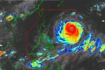
Metro Manila (CNN Philippines) — Typhoon Falcon (international name: Chan-hom) maintained its strength as it begins to move in a northwest direction, the Philippine Atmospheric, Geophysical and Astronomical Services Administration (PAGASA) said in its 11:00 a.m. severe weather bulletin on Thursday (July 9).
As of 10:00 a.m., Falcon’s eye was located 795 km east northeast of Itbayat, Batanes. It was packing maximum sustained winds of 130 kph near the center and gustiness of up to 160 kph.
It is forecast to move northwest at 22 kph.
No public storm warning signal was raised but PAGASA advised fisherfolk not to venture out over the seaboards of Luzon and Visayas.
Related: #WalangPasok: Class suspensions for July 9
The state weather bureau added that Falcon will enhance the southwest monsoon, which will bring moderate to occasionally heavy rains over Luzon and Visayas — especially over the western sections.
It said that the estimated rainfall amount is from heavy to at times intense within the 300 km radius of the typhoon.
Related: Project NOAH identifies Metro Manila flood prone areas
Forecast Positions
24 hour (Friday morning): Outside the Philippine area of responsibility (PAR) or at 620 km north northeast of Itbayat, Batanes