

LPA may develop into tropical depression as habagat dumps more rain over Luzon
Metro Manila, Philippines – The southwest monsoon or habagat will continue to bring heavy rain over large parts of Luzon on Tuesday, Aug. 18, as state weather bureau PAGASA monitors two low pressure areas (LPAs) near the country.
The rains come after flash floods hit parts of Metro Manila on Monday, Aug. 17, amid persistent bad weather.
In its 5 a.m. weather advisory, PAGASA said eight areas could receive 100 to 200 millimeters of rain on Tuesday.
Tuesday, Aug. 18
100-200 mm: Benguet, La Union, Pangasinan, Zambales, Bataan, Cavite, Batangas, and Occidental Mindoro
50-100 mm: Metro Manila, Ilocos Sur, Abra, Tarlac, Pampanga, Bulacan, Nueva Ecija, Laguna, Rizal, Oriental Mindoro, and Antique
Wednesday, Aug. 19
100-200 mm: Benguet, La Union, Pangasinan, Zambales, Bataan, and Occidental Mindoro
50-100 mm: Ilocos Sur, Tarlac, Pampanga, Bulacan, Nueva Ecija, Metro Manila, Cavite, Laguna, Batangas, Rizal, and Oriental Mindoro
Thursday, Aug. 20
50-100 mm: Ilocos Norte, Ilocos Sur, La Union, Benguet, Pangasinan, Zambales, Bataan, Tarlac, Pampanga, and Occidental Mindoro
PAGASA warned that rainfall could be higher in mountainous and elevated areas. The impact could also be worse in places that have already received significant rainfall in recent days.
Two LPAs monitored
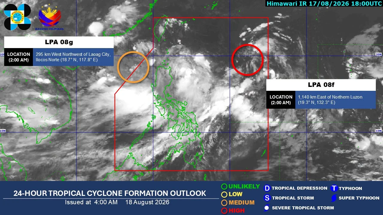
Meanwhile, PAGASA said at 2 a.m. Tuesday that a low pressure area inside the Philippine Area of Responsibility (PAR) had a high chance of developing into a tropical depression within the next 24 hours.
The LPA was located 1,115 kilometers east of Northern Luzon as of 3 a.m.
If it develops into a tropical depression, it would be given the local name ‘Neneng’. It is projected to move toward Taiwan, which is within the PAR.
PAGASA is also monitoring another LPA outside the PAR, located 295 kilometers west-northwest of Laoag City, Ilocos Norte, as of 3 a.m.
The second weather disturbance has a medium chance of developing into a tropical depression within 24 hours and is not expected to enter the PAR.
PAGASA earlier said potential tropical cyclones could further enhance the southwest monsoon and bring additional rain to parts of the country.
The weather bureau expects up to four tropical cyclones to develop within or enter the PAR in August.