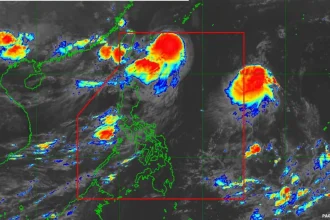

Metro Manila, Philippines – The weather bureau raised the highest storm alert in the central and northern portions of the Babuyan islands in the forecast path of Super Typhoon Nando on Monday, Sept. 22.
In its 8 a.m. advisory, the Philippine Atmospheric, Geophysical and Astronomical Services Administration (PAGASA) said ‘Nando’ may brush or hit land in extreme northern Luzon this afternoon. It added that the super typhoon may even intensify as it bears down on the island group under the jurisdiction of Cagayan province.‘Nando’ is now 215 kilometers per hour (kph) strong with gusts of up to 265 kph. It is moving westward at 20 kph, the weather bureau said. Meanwhile, areas under Signal 4 are the southeastern portion of Batanes, the northeastern and northwestern portions of mainland Cagayan, the northernmost portion of Ilocos Norte, and the rest of the Babuyan islands.Signal 3 is up in the rest of Batanes, the northern and central portions of mainland Cagayan, the northern and central portions of Apayao, and the northern and central portions of Ilocos Norte.Signal 2 covers the rest of Cagayan, Isabela, the rest of Apayao, Abra, Kalinga, Mountain Province, Ifugao, the northern portion of Benguet, the rest of Ilocos Norte, Ilocos Sur, and the northern portion of La Union.Twelve areas are under the lowest storm alert, namely:
+ Quirino
+ the rest of Nueva Vizcaya
+ the rest of Benguet
+ the rest of La Union
+ Pangasinan
+ Aurora
+ Nueva Ecija
+ Bulacan
+ Tarlac
+ Pampanga
+ Zambales
+ the northern portion of Quezon including Polillo Islands
PAGASA said ‘Nando’ may exit the tropical cyclone monitoring zone on Tuesday, Sept. 23.