
Metro Manila, Philippines – The northern portion of Catanduanes is under Signal No. 1 due to Tropical Depression Paolo on Wednesday afternoon, Oct. 1, the weather bureau said.
Resident in the towns of Pandan, Bagamanoc, Panganiban, and Viga may encounter winds that pose minimal to minor impact to life and property, the Philippine Atmospheric, Geophysical and Astronomical Services Administration (PAGASA) said in its 5 p.m. bulletin.
PAGASA said the storm may bring heavy rainfall on Thursday.
Northern and central Luzon were among the affected areas by the three consecutive storms last month.
PAGASA said “Paolo” may reach severe tropical storm category by early Friday morning.
“The highest wind signal that will likely be hoisted throughout its passage is Wind Signal No. 3,” the bureau said.
“However, since the possibility of reaching typhoon category before landfall is not ruled out, the worst case scenario is Wind Signal No. 4,” it added.
“Paolo” may make landfall over Isabela or northern Aurora on Friday morning or afternoon.
From a low pressure area on Tuesday, “Paolo” developed into a tropical depression on Wednesday morning.
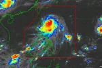
“Paolo” was last seen 665 kilometers (km) east of Virac, Catanduanes, packing maximum sustained winds of 55 km per hour (kph) near the center and gustiness of up to 70 kph.