
(CNN Philippines) – Typhoon #ChedengPH has weakened into a tropical storm while hovering the Philippine Sea on Saturday afternoon (April 4), several hours before its projected Easter morning landfall in Isabela, according to latest advisory from the Philippine Atmospheric, Geophysical and Astronomical Services Administration (PAGASA).
RELATED: No longer a typhoon, Maysak still a threat to Philippines
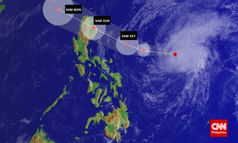
As of 6 p.m., Chedeng was spotted at 290 km southeast of Casiguran, Aurora, packing maximum sustained winds of 115 kph near the center and gustiness of up to 145 kph while taking a projected west-northwest direction at 20 kph.
Despite weakening to a tropical storm, Isabela and Aurora provinces were placed under Signal No. 3 as Chedeng continued to move closer to the said areas.
Based on PAGASA’s latest typhoon bulletin, the areas listed below are now under the following public storm warning signals:
Signal No. 3 (winds of 101-185 kph expected in at least 18 hours)
Isabela
Aurora
Signal No. 2 (winds of 61-100 kph expected in at least 24 hours)
Northern Quezon
Nueva Ecija
Southern Cagayan
Kalinga
Mt. Province
Ifugao
Benguet
Nueva Viscaya
Quirino
Catanduanes
Signal No. 1 (winds of 30-60 kph expected in at least 36 hours)
Rest of Cagayan including Babuyan Island
Apayao
Ilocos Norte
Ilocos Sur
Abra
La Union
Pangasinan
Tarlac
Pampanga
Bulacan
Rizal
Rest of Quezon including Polillo Island, Camarines Norte, and Camarines Sur
The estimated rainfall amount is from moderate to heavy within the 150 km radius of the tropical storm.
Maintaining its speed and movement, PAGASA said Chedeng – after its landfall over the coast of southern Isabela by Sunday morning – will exit the landmass via Ilocos Sur by Sunday afternoon (April 5), and will exit the Philippine territory by Monday morning (April 6).
RELATED: PAGASA now has four cyclone categories
Disaster preps
Meanwhile, national and local government agencies led by the National Risk Reduction and Management Council (NDRRMC) are in the thick of preparations for the onslaught of Chedeng, particularly in Isabela and Aurora.
‘ ’48’: ‘contentWidth’: ‘100%’ ’embedCode’: ‘
DENR-MGB nagpalabas ng listahan ng mga flood at landslide-prone areas sa Aurora at Isabela #ChedengPH pic.twitter.com/ZE5NrQRoyh
— NDRRMC (@NDRRMC_OpCen) April 4, 2015
‘
Rescue teams from the Metropolitan Manila Development Authority (MMDA) as well as local government units in Metro Manila including Muntinlupa, Mandaluyong, Quezon City, and Manila headed for the said provinces on Saturday afternoon to bring rescue equipment, food, and water treatment facilities.
The NDRRMC said some of the municipalities in these areas, especially those from the coastal communities, have conducted preemptive evacuation as of posting time. It is also closely monitoring Lamon Bay in Bicol as a storm surge may occur in this area.
The national disaster council said it is highly unlikely that Chedeng will have a direct effect on Metro Manila, but nevertheless made the necessary preparations by taking down tarpaulins and billboards in anticipation of the storm.
The Department of Social Welfare and Development, on the other hand, assured the public that enough relief goods have already been prepositioned in the provinces affected by Chedeng.
The DSWD said it has about P19 million worth of food packs situated in the affected areas – enough to serve about five million persons for the first three days.
‘ ’60’: ‘contentWidth’: ‘100%’ ’embedCode’: ‘
DSWD prep 318,263 food packs worth P111,502,123.06 & standby funds of P22,145,000 transferred to Regions I,II,III,IVA,IVB,V,VIII,NCR&CAR
— Department of Social Welfare and Development (@dswdserves) April 4, 2015
‘
Soliman expressed confidence that the DSWD will not lack in relief goods as another 79 thousand food packs have been repacked and are ready for disposal should the need arises.
In Baler, Aurora around 10,000 people, including foreign and domestic tourists were asked to end their vacation and leave the area.