
(CNN Philippines) — Typhoon Chedeng (International name: Maysak) is no longer a super typhoon after entering Philippine territory at 11 p.m. on Wednesday (April 1).
From its earlier super typhoon status, Chedeng has further weakened, according to the Philippine Atmospheric, Geophysical, Astronomical Services Administration (PAGASA).
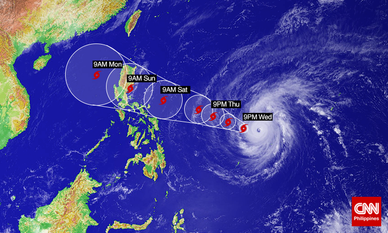
In its 5 p.m. bulletin on Friday, PAGASA estimated Chedeng to be traveling at 19 kph toward the eastern coast of Central Luzon, as of 4 p.m. on Good Friday (April 3).
It was located at 845 km east-southeast of Casiguran, Aurora, with maximum sustained winds of 140 kph and gustiness of up to 170 kph.
PAGASA has also raised raised Storm Signal No. 1 in Isabela, Aurora, Quirino, Quezon including Polillo Island, Catanduanes, Camarines Norte, and Camarines Sur.
The state weather bureau predicts that Chedeng will make landfall over eastern coast of Aurora-Isabela area by Saturday evening (April 5), and exit the landmass via Ilocos Sur by Sunday evening (April 6)
The state weather bureau has predicted that the whole archipelago will experience partly cloudy to cloudy skies with isolated showers or thunderstorms on Good Friday.
It also warned that the eastern section of the country will experience moderate to rough seas.
Just before it assumed the local name, Maysak hovered over the Pacific Ocean with winds gusting as stong as as 250 kph, according to a Reuters report. It intensified into a Category 5 hurricane Tuesday evening (March 31), prompting the U.S. Joint Typhoon Warning Center (JTWC) to elevate it into super typhoon status.
The typhoon’s status falls in line with PAGASA’s earlier forecasts — the weather bureau earlier projected Maysak to weaken once it hits central or northern Luzon this Sunday.
“This is very strong and it will maintain its strength as it nears, although we expect that the typhoon will weaken,” said PAGASA weather division chief Esperanza Cayanan.
“But this will still be typhoon intensity so it will bring strong winds when it makes landfall on the eastern coast.”
PAGASA is set to raise storm warning signals over Bicol and other regions of eastern Luzon within the day with the entry of Chedeng.
Interior Secretary Manuel “Mar” Roxas II, meanwhile, has called on mayors and governors of Eastern Visayas and Southern Luzon as early as Tuesday to stand guard and be ready for Chedeng.

“The mayors are the first responders,” said Roxas. “They should man the command centers in their respective localities.”
On Tuesday, the Japan Meteorological Agency (JMA) categorized Maysak as a “violent” super typhoon after it intensified into a powerful howler equivalent to a Category 5 hurricane. It later pummeled the tiny island of Yap in the Federated States of Micronesia with strong winds and heavy rain.
Prior to becoming a super typhoon, Maysak already caused significant damage and reportedly killed at least five people in the Chuuk state of Micronesia.
The typhoon was earlier predicted to be as severe as Tropical Cyclone Pam, which ravaged Vanuatu two weeks ago.
In November 2013, Typhoon Haiyan (local name: Yolanda) hit parts of Visayas packing maximum winds of 230 kph and gustiness of 315 kph. Haiyan is also the strongest typhoon recorded at landfall in world history, killing at least 6,300 people in the Philippines alone.
Tropical Cyclone Pam, on the other hand, was one of the worst natural disasters to hit the island nation of Vanuatu in the South Pacific, leaving 11 people dead and tens of thousands residents homeless.
Meanwhile, PAGASA said it will raise Public Storm Warning Signal #1 within the next 12 hours over Bicol and Samar provinces, making sea travel over these areas possibly suspended.
CNN Philippines’ Paul Garcia contributed to this report