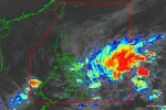

Metro Manila (CNN Philippines) — Philippine Atmospheric, Geophysical and Astronomical Services Administration (PAGASA) warned of possible storm surges in the northern areas of the country, as Typhoon Lando maintained its strength on Friday afternoon (October 16).
As Typhoon Lando moved closer to the Isabela-Aurora area, PAGASA weather forecaster Aldczar Aurelio said on Friday that possible storm surges of 0.9 to 1.2 meters can occur in the provinces of Quezon and Camarines from 8 a.m. to 8 p.m. Saturday.
Lando is carrying maximum sustained winds of 130 kph near the center and gustiness of up to 160 kph, as of 4 p.m. Friday. It was forecast to be moving west at 15 kph.
Lando is expected to make landfall over Isabela-Aurora area on Sunday morning. It will then cut through Quirino, Nueva Vizcaya, Mountain Province, Abra, and Ilocos Norte.
Moderate to occasionally intense rainfall can be expected over Northern and Central Luzon and Metro Manila starting Saturday and this can last until Monday (October 19).
Public storm warning signals are up in the following areas:
Signal no. 2:
Aurora
Isabela
Quirino
Nueva Vizcaya
Nueva Ecija
Northern Quezon, including Polillo Island
Signal No. 1:
Cagayan
Abra
Kalinga
Mt. Province
Ifugao
Benguet
Ilocos Sur
La Union
Pangasinan
Bulacan
Pampanga
Tarlac
Zambales
Bataan
Rizal
Laguna
rest of Quezon
Camarines Norte
Camarines Sur
Catanduanes
Metro Manila
Lando is expected to exit the Philippine area of responsibility by early morning of Tuesday (October 20).