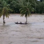

Metro Manila, Philippines – Twenty-three areas are under Wind Signal No. 1 as Severe Tropical Storm Leon moves closer to the country, the Philippine Atmospheric, Geophysical, and Astronomical Services Administration (PAGASA) said in its bulletin.
Meteorologists last spotted the storm east of Echague, Isabela, with sustained winds of 100 kilometer per hour (km/h) and gusts of up to 125 km/h.
As of 5 p.m. on Monday, Oct. 28, cyclone wind Signal No. 1 was hoisted in 23 areas in Luzon. These are:
+ Batanes
+ Cagayan including Babuyan Islands
+ Isabela
+ Apayao
+ Kalinga
+ Quirino
The warning means winds of 39 to 61 kilometers per hour (km/h) and intermittent rains may be expected over these areas in the next 36 hours.
“The highest wind signal which may be hoisted during the occurrence of Leon is wind Signal No. 3 or 4, especially in extreme northern Luzon,” PAGASA said.
It added that the storm may intensify into a typhoon in the next 24 hours. It may reach super typhoon category during its closest approach to Batanes on Wednesday (Oct. 30) or Thursday (Oct. 31), the weather bureau said.
The agency also warned it is not ruling out a landfall scenario over the island.
PAGASA said the storm may exit the Philippine Area of Responsibility on Friday, Nov. 1.
+ Nueva Vizcaya
+ Abra
+ Mountain Province
+ Ifugao
+ northern portion of Benguet
+ Ilocos Norte
+ Ilocos Sur
+ La Union
+ Aurora
+ northern portion of Quezon including Polillo Islands
+ Camarines Norte
+ eastern portion of Camarines Sur
+ Catanduanes
+ eastern portion of Albay
+ northeastern portion of Sorsogon
+ eastern portion of Northern Samar
+ northern portion of Eastern Samar