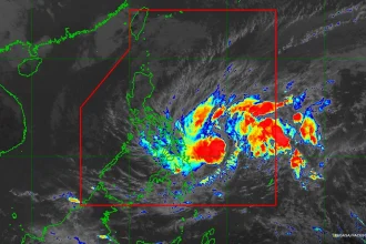

Metro Manila, Philippines – Tropical Storm Enteng keeps its strength after making landfall in Casiguran, Aurora on Monday afternoon, according to state weather bureau PAGASA.
“At 2:00 pm today, based on all available data including from Baler Weather Radar, the center of Tropical Storm ENTENG made landfall in the vicinity of Casiguran, Aurora,” PAGASA announced.
PAGASA reported that Enteng still packed maximum sustained winds of 85 kilometers per hour (km/h) near the center and gusts reaching up to 105 km/h. The storm moved north northwestward at 20 km/h.
At 4 p.m., the center of the storm was spotted in the vicinity of Maddela, Quirino.
PAGASA warned of heavy rainfall of up to 200 millimeters in parts of Luzon until Wednesday afternoon, Sept. 4:
Today to tomorrow (Sept. 3) afternoon
100-200 mm: Ilocos Region, Nueva Vizcaya, Quirino, Isabela, Apayao, Abra, Benguet, and the northern and central portions of Aurora
50-100 mm: Zambales, Bataan, Nueva Ecija, Bulacan, Rizal, Metro Manila, and the rest of Cagayan Valley, Cordillera Administrative Region, and Ilocos Region
Tomorrow afternoon to Wednesday (Sept. 4) afternoon
100-200 mm: Ilocos Sur and Abra
50-100 mm: The rest of Ilocos Region, and Benguet
“[T]he enhanced southwest monsoon will bring moderate to intense rainfall in other areas of Luzon and Visayas (especially along the western portions) over the next three days,” PAGASA said.
The storm is expected to leave the Philippine Area of Responsibility – the monitoring space for weather disturbances – on Wednesday.
Storm signals
Tropical Cyclone Wind Signal No. 2, indicating “minor to moderate impacts from strong winds,” has been raised in seven areas in Luzon, down from nine earlier in the day.
+ Ilocos Norte
+ Apayao
+ eastern portion of Kalinga (Rizal, Pinukpuk, City of Tabuk)
+ Cagayan including Babuyan Islands
+ Isabela
+ Quirino
+ northern portion of Aurora (Casiguran, Dilasag, Dinalungan, Dipaculao, Baler)
Polillo Islands is now under Signal No. 1, while all storm signals lifted for Camarines Norte.
Other areas under Signal No. 1 include:
+ Batanes
+ Ilocos Sur
+ La Union
+ eastern portion of Pangasinan (Rosales, Asingan, Binalonan, Sison, San Manuel, Santa Maria, Balungao, San Quintin, Tayug, Umingan, Natividad, San Nicolas)
+ Abra
+ rest of Kalinga
+ Mountain Province
+ Ifugao
+ Benguet
+ Nueva Vizcaya
+ rest of Aurora
+ Nueva Ecija
+ eastern portion of Bulacan (Doña Remedios Trinidad, Norzagaray, City of San Jose del Monte, Obando, City of Meycauayan, Bocaue, Balagtas, Bustos, Baliuag, Pandi, Santa Maria, Marilao, Angat, San Rafael, San Ildefonso, San Miguel)
+ Metro Manila
+ Rizal
+ northeastern portion of Laguna (Santa Maria, Mabitac, Pakil, Pangil, Famy, Siniloan)
+ northern portion of Quezon (General Nakar, Infanta, Real) including Polillo Islands
“The highest possible wind signal that may be hoisted during the passage of Enteng is Wind Signal No. 3,” PAGASA said.
Warnings
PAGASA warned that the enhanced southwest monsoon will bring strong gale-force gusts in the following areas:
Today: Ilocos Region, Aurora, Zambales, Bataan, Bulacan, Metro Manila, CALABARZON, MIMAROPA, Bicol Region, and Visayas
Tomorrow (Sept. 3): Ilocos Region, Nueva Vizcaya, Quirino, Zambales, Bataan, Aurora, Bulacan, Metro Manila, CALABARZON, MIMAROPA, Bicol Region, Western Visayas, Negros Island Region, Northern Samar
Wednesday (Sept. 4): Ilocos Region, Abra, Benguet, Zambales, Bataan, Bulacan, Aurora, Metro Manila, Calabarzon, Mimaropa, Bicol Region, Western Visayas, Negros Occidental, Northern Samar
The weather bureau added that a minimal to moderate risk of storm surge may occur in the next 48 hours in the low or exposed coastal localities of Batanes, Cagayan, Isabela, Ilocos Norte, Ilocos Sur, and Aurora.
A gale warning is in effect for the eastern seaboard of Luzon and the southern seaboard of Southern Luzon, making sea travel risky for small seacrafts and motor bancas, PAGASA said.
It expects moderate to rough seas over the northern seaboard of Northern Luzon, the western seaboard of Central Luzon, the western and southern seaboards of Southern Luzon (outside gale warning areas), and Western Visayas.
“Mariners of small seacrafts, including all types of motor bancas, are advised not to venture out to sea under these conditions, especially if inexperienced or operating ill-equipped vessels.” PAGASA said.
Slight to moderate seas are anticipated elsewhere in the country, PAGASA said, advising small vessels to take precautions and, if possible, avoid sea travel under these conditions.