
Metro Manila, Philippines — “Pepito” has intensified into a super typhoon, the Philippine Atmospheric, Geophysical and Astronomical Services Administration (PAGASA) said on Saturday.
As of 11 a.m., Wind Signal 4 is raised over Catanduanes and the northeastern portion of Camarines Sur. Winds of 118 kilometers per hour (kph) to 184 kph are expected.
The following areas may experience 89 to 117 kilometers per hour (kph) wind speeds under Signal 3: the eastern portion of Camarines Norte, northern and southeastern portion of Camarines Sur, eastern portion of Albay, the northeastern portion of Sorsogon, the eastern portion of Northern Samar, and the northern portion of Eastern Samar.
The following are under Wind Signal 2 and can expect 62 to 88 kph of wind speeds: the southeastern portion of Isabela, Aurora, Quezon, the eastern portion of Rizal, Laguna, the rest of Camarines Norte, the rest of Camarines Sur, the rest of Albay, the rest of Sorsogon, Burias Island, and Ticao Island, The central portion of Eastern Samar, the northern portion of Samar, and the rest of Northern Samar.
Meanwhile, the areas under the lowest wind signal with wind speeds of 39 to 61 kph are: Mainland Cagayan, the rest of Isabela, Quirino, Nueva Vizcaya, Apayao, Kalinga, Abra, Mountain Province, Ifugao, Benguet, Ilocos Norte, Ilocos Sur, La Union, and Pangasinan, Nueva Ecija, Bulacan, Tarlac, Pampanga, Zambales, Bataan, Metro Manila, the rest of Rizal, Cavite, Batangas, Marinduque, the northern portion of Oriental Mindoro, Romblon, and the rest of Masbate, the rest of Eastern Samar, the rest of Samar, Biliran, the northern and central portions of Leyte, the northeastern portion of Southern Leyte, the northernmost portion of Cebu including Bantayan Islands, and the northernmost portion of Iloilo, and the northern portion of Dinagat Islands.
Threats
PAGASA warned that there is a high risk of a life-threatening storm surge over low-lying areas or exposed local communities of Eastern Samar, Northern Samar, Bicol, Marinduqe, Calabarzon, Metro Manila, Central Luzon, Isabela, Ilocos Region, Biliran and Leyte.
A gale warning is up over the eastern and southern seaboards of Southern Luzon and the eastern coast of Visayas.Intense to torrential rains, or more than 200 millimeters, are expected over Catanduanes.Camarines Sur, Northern Samar, and Eastern Samar may have heavy to intense rains or about 100 to 200 millimeters.Moderate to heavy rains, or 50 to 100 millimeters, may pour over Camarines Norte, Albay, Sorsogon, Samar, Leyte, Biliran, and Masbate.
Landfall scenario
Pepito will cross over or near the landmass of Bicol, Quezon, Central Luzon, Benguet, La Union, and Pangasinan over the weekend.PAGASA said Pepito may touch the landmass of Catanduanes Saturday night or Sunday morning.
The agency is also not ruling out the possibility of a landfall over Camarines Sur or Albay during the same time frame.
Pepito may also meet the landmass of Quezon or Aurora Sunday afternoon or evening.
Location, strength
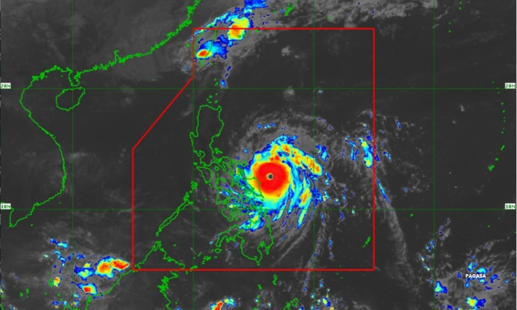
At 10 a.m., Pepito was seen 185 kilometers east of Catarman, Northern Samar or 250 kilometers east of Juban, Sorsogon.
It has maximum sustained winds of 185 kph and gustiness, or bursts of winds, of up to 230 kph.
The weather disturbance is moving 25 kph northwestward.