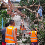

Metro Manila, Philippines — Three areas are under wind signal No. 3 as Severe Tropical Storm Kristine moves over coastal waters off southern Ilocos Sur on Thursday afternoon, Oct. 24.
In its 5 p.m. bulletin, the Philippine Atmospheric, Geophysical, and Astronomical Services Administration (PAGASA) said Signal No. 3 remains over Benguet, Ilocos Sur, La Union, and Pangasinan.
Signal No. 2 covers Benguet, Ilocos Norte, Batanes, Cagayan including Babuyan Islands, Isabela, Quirino, Nueva Vizcaya, Apayao, Kalinga, Abra, Ifugao, Mountain Province, Aurora, Nueva Ecija, Tarlac, Zambales, Bataan, Pampanga, Bulacan.
Signal No. 1 was raised over the following areas:
+ Luzon: Batanes, Metro Manila, Rizal, Cavite, Laguna, Batangas, Quezon, Occidental Mindoro, Oriental Mindoro, Marinduque, Romblon, the northern portion of mainland Palawan including Calamian Islands, Cuyo, and, Kalayaan Islands, Camarines Norte, Camarines Sur, Catanduanes, Albay, Sorsogon, and Masbate including Ticao and Burias Islands;
+ Visayas: Aklan, Capiz, Antique including Caluya Islands, Iloilo, Bantayan Islands, Northern Samar, and the northern portion of Samar.
Possible typhoon category
PAGASA said the low pressure area east of the country but still outside the Philippine Area of Responsibility (PAR) would affect “Kristine.”
Once “Kristine” exits PAR on Friday afternoon, it might loop over the West Philippine Sea on Sunday and move towards the PAR boundary.