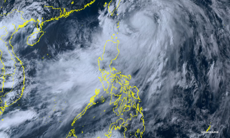

Metro Manila, Philippines—Typhoon Carina (international name: Gaemi) has intensified as it moves northward, enhancing the southwest monsoon, state weather bureau PAGASA said in its 5 p.m. bulletin.
The agency said heavy rainfall is expected in Batanes, Babuyan Islands, the northern and eastern portion of mainland Cagayan, and Ilocos Sur.
In addition, the southwest monsoon or habagat enhanced by ‘Carina’ is bringing moderate to intense rain over the western portion of Luzon through Thursday.
PAGASA said ‘Carina’ packs maximum sustained winds of 150 kilometers pr hour (kph), with gusts of up to 185 kph. Its eye was last spotted 325 km east northeast of Basco, Batanes.
Tropical cyclone wind signal no. 2 is up in Batanes with winds of 62 km/h and up to 88 km/h may be expected in at least 24 hours.
Tropical cyclone wind signal no.1 has been raised in the following areas:
Cagayan including Babuyan Islands
Eastern portion of Isabela (Divilacan, Palanan, Maconacon, Dinapigue, Tumauini, Ilagan City, San Mariano, Cabagan, San Pablo, Santa Maria)
Northern portion of Apayao (Calanasan, Luna, Pudtol, Flora, Santa Marcela, Kabugao)
Northern portion of Ilocos Norte (Pagudpud, Bangui, Adams, Dumalneg, Burgos, Vintar, Pasuquin, Bacarra, Carasi)
Winds of 39-61 km/h may be expected in at least 36 hours or intermittent rains may be expected within 36 hours.
Earlier, Malacanang suspended government work and classes in all levels in Metro Manila due to non-stop rains.