
Metro Manila (CNN Philippines, July 16) — The state weather bureau on Sunday warned of flooding and landslides as the enhanced southwest monsoon, or habagat, continues to bring rains over Luzon and Western Visayas.
According to the Philippine Atmospheric, Geophysical and Astronomical Services Administration (PAGASA), Zambales, Bataan, Occidental Mindoro, and the northern portion of Palawan may experience heavy and continuous rains.
Occasional rains are forecast over Metro Manila, Western Visayas, La Union, Pangasinan, Benguet, Tarlac, Pampanga, Bulacan, Cavite, Batangas, and the rest of Mimaropa.
The rest of Luzon may see cloudy skies with scattered rain showers and thunderstorms.
“May kakapalan ang mga kaulapan dito sa Luzon at western section ng Visayas kaya nananatiling mataas ang tiyansa ng mga flash flood at landslide sa mga nabanggit na lugar,” PAGASA weather specialist Daniel Villamil said during a 5 a.m. briefing.
[Translation: There are thick clouds over Luzon and the western section of Visayas that’s why flashfloods and landslides may occur in these areas.]
Meanwhile, Mindanao and the rest of Visayas may expect partly cloudy to cloudy skies with isolated rain showers or thunderstorms due to the habagat and localized thunderstorms.
Villamil said rains will continue over Luzon, especially over the northern and the central areas of the island, until Tuesday. By Wednesday, the cities of Metro Manila, Baguio, and Legazpi may experience generally fair weather conditions with rains caused by localized thunderstorms.
The central and eastern sections of Visayas and Mindanao may experience gloomy weather until Wednesday as PAGASA is monitoring a cloud cluster over the east of Mindanao but still outside the Philippine Area of Responsibility (PAR), Villamil said.
“Hindi tinatanggal ang posibilidad na ang mga kumpol ng kaulapan na ito ay mamuo bilang isang low pressure area sa mga susunod na araw,” he added.
[Translation: We are not eliminating the possibility of the cloud cluster developing into a low pressure area in the coming days.]
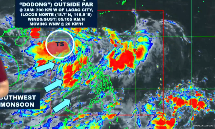
Dodong, which peaked at tropical storm category before exiting the PAR on Saturday afternoon, has no direct impact on any part of the country, but it has enhanced the habagat, PAGASA said.
The storm is expected to intensify into a typhoon while moving towards southern China, the agency added.
PAGASA also raised a gale warning over the western seaboards of Luzon and Visayas, advising against vessels sailing as the height of waves ranges from 2.8 to 4.5 meters.