
In a social media post, the Philippine Atmospheric, Geophysical and Astronomical Services Administration (PAGASA) said the weather system, now called Henry, entered the Philippine Area of Responsibility at 5:30 p.m.
It maintained strong winds of 195 kilometers per hour and gusts of up to 240 kph, PAGASA weather specialist Raymond Ordinario said in the agency’s latest briefing.
He noted that the super typhoon will enter the north boundary of the weather monitoring area, but it will still have no direct effect on the country.
The agency also warned that Tropical Cyclone Wind Signal No. 3 may be raised as it moves closer to extreme northern Luzon.
Ordinario said the super typhoon will be closest to Batanes, Calayan, and Babuyan Islands by Friday.
Moderate to occasionally heavy rains are forecast in parts of the Ilocos and Cordillera regions, as well as in the Zambales-Bataan area and Central Luzon by Thursday, said PAGASA weather services chief Juanito Galang.
PAGASA said Henry’s movement is dependent on two high-pressure areas in Japan and China which can slow down its track in the northern part of the Philippines.
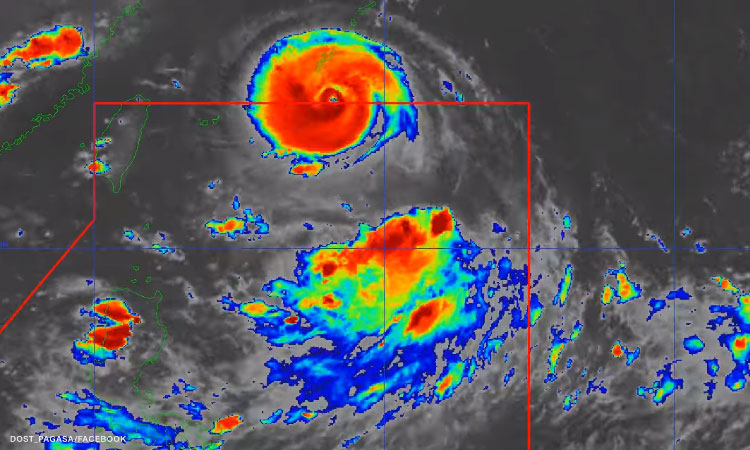
The bureau also reported that Tropical Depression Gardo is expected to be downgraded into a low pressure area within 12 hours, then “merge” with the circulation of Henry.
It earlier said that such scenario may also enhance the southwest monsoon or “habagat” and trigger heavy rains over Luzon this week.
“Another scenario that we’re looking at is the possibility of the merging of Gardo and the super typhoon and this will expand the cloudiness of the super typhoon and might also enhance the habagat,” Ordinario told CNN Philippines’ New Day. “If the deeper trough of Hinnamnor will reach Batanes area, some of the western section of northern Luzon will expect a ‘habagat effect’ in the coming days.”
He added that it is possible Henry will not enhance the southwest monsoon if it moves toward extreme northern Luzon then simply head to southern Japan.
PAGASA weather forecaster Grace Castañeda said in a separate update that Henry’s scope may continue to widen in the coming days. This may prompt authorities to raise tropical cyclone wind signal alerts over extreme northern Luzon, particularly Batanes and Babuyan Islands.
Henry is not expected to have immediate direct impact in the country. It is forecast to remain almost stationary by late Thursday through Friday.
Gardo was last spotted 1,040 km east of northeast of extreme northern Luzon, maintaining maximum sustained winds of 55 kph near the center, and gustiness of up to 70 kph, PAGASA said in its 11 p.m. bulletin.
Metro Manila (CNN Philippines, August 31) — Super Typhoon Hinnamnor entered the country’s weather monitoring area, the state weather bureau said Wednesday.
It was moving north northwestward at 20 kmh, not having any direct effect on the country, it added.
Ordinario said Henry is unlikely to make landfall.
It may also bring rough seas over the northern and eastern seaboards of Luzon beginning late Thursday or early Friday.
Meanwhile, Ordinario said PAGASA is still not seeing any landfall scenario for Gardo, which turned into a tropical depression at 2 p.m. on Tuesday.
It also has no direct impact on the country but it will bring rains in the western section of Central Luzon and Southern Luzon, including Metro Manila.
For the coming days, PAGASA also said cloudy skies with scattered rain showers and thunderstorms may be expected over Metro Manila, Calabarzon, Mimaropa, Bicol Region, Ilocos Region, Cordillera Administrative Region, Batanes, Zambales, and Bataan due to the trough of Gardo and the southwest monsoon.
Light to moderate with at times heavy rains are also expected in the extreme northern Luzon beginning late Thursday or Friday due to Henry.