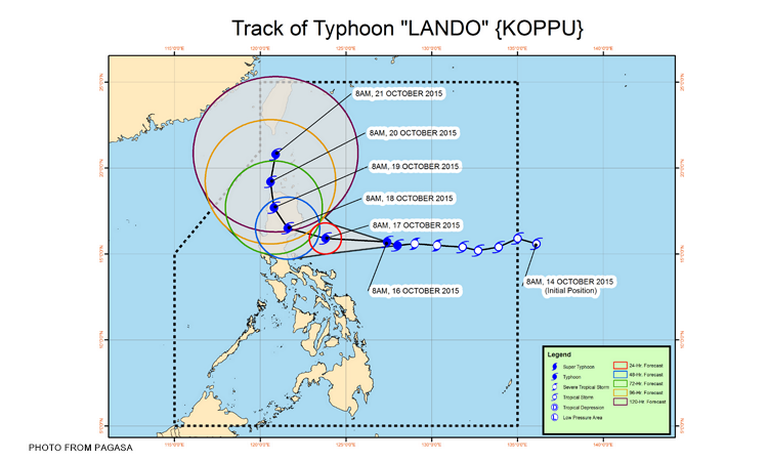

Metro Manila (CNN Philippines) — Typhon Lando (international name: Koppu) continued to gain strength on Friday morning (October 16) as it moved toward the Aurora-Isabela area, the Philippine Atmospheric, Geophysical, and Astronomical Services Administration (PAGASA) said in its severe weather bulletin issued at 11 a.m. the same day.
The state weather bureau spotted the storm 585 km wast of baler at 10 a.m. It said that the typhoon packed maximum sustained winds of 130 kph near the center and gustiness of up to 160 kph. It expects Lando to move west at 15 kph.
Rainfall is expected to be heavy to intense within the 550 km diameter of the typhoon. PAGASA has advised fisherfolk to not venture out over the northern and western seaboards of Northern Luzon, the western seaboard of Central Luzon, and the eastern seaboard of Visayas.
Public Storm Warning Signal No. 2 has been raised over Aurora and Isabela, as the state weather bureau expects 61-120 kph winds in such areas over the next 24 hours.
PAGASA has also raised Public Storm Signal No. 1 over the following areas:
Cagayan
Kalinga
Mt. Province
Ifugao
Benguet
Quirino
Nueva Vizcaya
Nueva Ecija Bulacan
Pampanga
Tarlac
Pangasinan
Rizal
Quezon, including Polillo Island
Camarines Norte
Camarines Sur
Catanduanes
PAGASA expects the storm to be 240 km east of Baler, Aurora by Saturday morning (October 17).