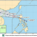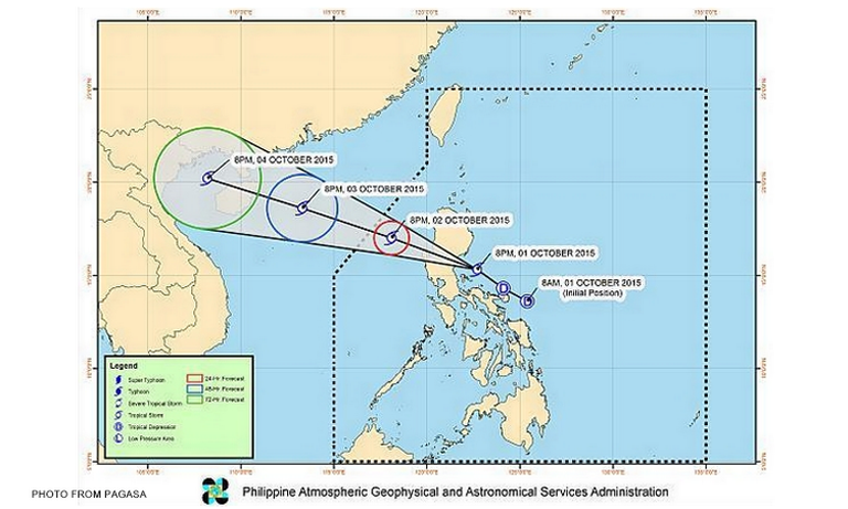

Metro Manila (CNN Philippines) — Kabayan has intensified into a tropical storm, according to the bulletin issued at 11 p.m. on Thursday (October 1) by the Philippine Atmospheric, Geophysical and Astronomical Services Administration (PAGASA).
As of 10 p.m., the storm, internationally known as Mujigae, was at 170 km north-northeast of Daet, Camarines Norte, or 85 km east-southeast of Baler, Aurora.
Moving west-northwest at 20 kph, the storm has maximum sustained winds of 65 kph near the center, with a gustiness of up to 80 kph.
Bringing moderate to heavy rainfall within its 300 km diameter, it’s expected to make landfall over Aurora province sometime between 2 a.m. and 4 a.m. on Friday (October 2).
The following storm signals have been raised over several areas in Luzon”
Signal No.2 (bringing winds of 61 to 120 kph in at least 24 hours)
Aurora
Northern Quezon including Polillo Island
Quirino
Nueva Vizcaya
Benguet
La Union
Pangasinan
Tarlac
Nueva Ecija
Signal No. 1 (bringing winds of 30 to 60 kph in at least 36 hours)
Isabela
Ifugao
Mountain Province
Kalinga
Abra
Ilocos Sur
Zambales
Pampanga
Bataan
Bulacan
Rizal
Rest of Quezon
Camarines Norte
Metro Manila
There will be moderate to occasionally heavy rains and isolated thunderstorms over Mimaropa, Bicol Region, Western Visayas, and the provinces of Cavite, Laguna, and Batangas.
Residents in low lying and mountainous areas of areas under Storm Signals No. 1 and No.2 should watch out for possible flash flooding and landslides.
Sea travel is risky over the eastern seaboard of Northern and Central Luzon and the eastern seaboard of Quezon, including Polillo Island.
PAGASA made the following prediction of the storm’s path:
By Friday evening: 250 km west[-southwest of Vigan City, Ilocos Sur
By Saturday evening: 770 km West of Laoag City, Ilocos Norte or outside the Philippine territory
By Sunday evening: 1,440 km West of Basco, Batanes